3dforest.htm
3D-Forest (BELSPO STEREO)
Novel in-situ 3D forest structure and biomass estimates to validate air/spaceborne products
(Duration: October 2017 – September 2020)
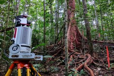
Forests are the ecosystem that contains most biomass. However, estimating biomass without cutting the trees is not easy. Traditional methods of estimating biomass are based on relationships between destructive estimates of volume and diameter and/or height, which can be measured more easily in the field. However, harvesting trees is expensive and often impractical. Terrestrial laser scanning (TLS) has the potential to go beyond simple allometric relationships by providing a detailed three dimensional characterization of forest structure. TLS involves using an instrument to scan forests from multiple locations on the ground to build a 3D image. From these very detailed images, we can accurately calculate tree parameters such as height, diameter and volume. TLS is labor-efficient and can help study small trees, which are overlooked in traditional inventories. We will develop a framework to assess the quality of TLS volume estimates and use these estimates to develop new equations for estimating biomass.
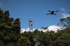
We will also acquire ground-based and UAV (unmanned aerial vehicle or drone) laser scanning data at the same time. We will investigate how the fusion of data from ground-based and UAV LiDAR improves our biomass estimates and how we can upscale plot-based measurements to landscape level. Finally, we will use TLS input instead of traditional inventory data to improve forest growth models. The detailed TLS data is expected to produce more reliable models to predict biomass in forests. The techniques, methods, applications and knowledge developed in this project will provide new insights into the assessment, upscaling and dynamics of biomass. This project will focus on temperate (SONIA site) and tropical forests. The gained insights will be of high relevance for decision makers and natural resource managers. Moreover, more reliable biomass estimates will be essential for the validation and calibration of three upcoming satellite missions (ESA BIOMASS, NASA GEDI, NISAR)
Principal Investigator
dr. ir. Kim Calders
Faculty of bioscience engineering, Campus Coupure, room A2.089
+32 (0) 264 61 13
Kim.Calders@ugent.be
Prof. dr. ir. Hans Verbeeck
Faculty of bioscience engineering, Campus Coupure, room A2.089
+32 (0) 264 61 13
Hans.Verbeeck@UGent.be
Prof. dr. Martin Herold
Wageningen University
martin.herold@wur.nl
dr. Harm Bartholomeus
Wageningen University
Harm.Bartholomeus@wur.nl
Collaborations
University College London (Andrew Burt, Mathias Disney)
Wageningen University (Alvaro Lau, Benjamin Brede)
University of Maryland (John Armston, Laura Duncanson)
TLS-RCN community (http://tlsrcn.bu.edu/
Master students 2018-2019
Louise Terryn
Topic: Tree species recognition using 3D terrestrial laser scanning
Barbara D’hont
Topic: Quantifying structural differences between different tropical forests
Project Publications
Verbeeck, H., Bauters, M., Disney., M., Calders, K. (in review) Time for a plant structural economics spectrum. Frontiers in Forest and Climate Change.
Brede, B., Calders, K., Lau, A., Raumonen, P., Bartholomeus, H., Herold, M., Kooistra, L. Tree Volume Estimation through UAV Laser Scanning and Quantitative Structure Modelling. (in review, remote sensing of environment)
Burt, A., Disney, M., Calders, K. (2019) Extracting individual trees from lidar point clouds using treeseg. Methods in Ecology and Evolution, 10:438–445.
Duncanson, L., Armston, J., Disney, M., Avitabile, V., Barbier, N., Calders, K., et al. (2019) The Importance of Consistent Global Forest Aboveground Biomass Product Validation. Surveys in Geophysics. https://doi.org/10.1007/s10712-019-09538-8
Lau, A., Calders, K., Bartholomeus, H., Martius, C., Raumonen, P., Herold, M., Vicari, M., Sukhdeo, H., Singh, J. and Goodman, R.C. (2019) Tree Biomass Equations from Terrestrial LiDAR: A Case Study in Guyana. Forests, 10, 527.
Marselis S., Tang, H., Armston, J., Calders, K., Labrière, N. and Dubayah, R. (2018) Distinguishing vegetation types with airborne waveform lidar data in a tropical forest-savanna mosaic: a case study in Lopé National Park, Gabon. Remote Sensing of Environment, 216, 626-634.
Project Conference Contributions
Calders, K., Bartholomeus, H., Herold, M., Whiteside, T., Bartolo, R., Levick, S. & Verbeeck, H. (2019) Comparing Terrestrial and UAV LiDAR for Monitoring Forest Structure. SilviLaser 2019, 8-10 October, Iguazu Falls, Brazil.
Calders, K., Bartholomeus, H., Herold, M., D’hont, B., Terryn, L. & Verbeeck, H. (2019) Fusion of Terrestrial and UAV LIDAR for Monitoring Forest Structure, ESA Living Planet, 13-17 May 2019, Milan, Italy.
Calders, K., Disney, M., Burt, A., Origo, N., Nightingale, J., Malhi, Y., Wilkes, P., Raumonen, P.,& Verbeeck., H. Developing new biomass allometric equations based on terrestrial laser scanning. ForestSAT 2018, 1-5 October 2018, Maryland, USA.
Brede, B., Pasi, R., Calders, K., Alvaro, L., Bartholomeus, H., Herold, M., Kooistra, L., 2018. Geometric Tree Modelling with UAV-based Lidar. 5-7/9/2018 Earsel - 1st Workshop UAS “UAS for mapping and monitoring”, Warsaw, Poland.
Media and Outreach Activities
https://www.tern.org.au/Newsletter-2018-Nov-Virtual-Forests-pg32694.html
https://lidarnews.com/articles/novel-lidar-data-tropical-forests/
https://eo.belspo.be/en/news/3d-forest-understanding-tropical-forests-help-lidar

