Lake Chad
Imaging radar for mapping and monitoring of wetland ecosystems in the Lake Chad Basin
Funded by: The Belgian Federal Office for Scientific, Technical and Cultural Affairs (OSTC) - project T4/02/35, and ESA (imagery supply in the framework of AO3-151); Collaboration with IUCN Waza-Logone project for field data acquisition.
Research associate: Jan Verhoeye
Promotor: Robert De Wulf
Duration: 12/1998 – 06/2001
Project objectives
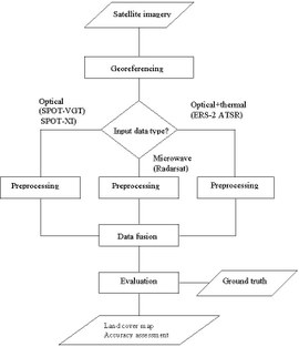
The focus of this research programme is to determine whether the combination of radar with optical data increases the accuracy of the resultant land cover map. While optical data represent the reflective properties of ground cover, microwave data are sensitive to the shape, roughness and moisture content of the observed objects. Another topic of research pertains to the evaluation of the presence of synergy when combining optical data with different spatial resolution. Coarse spatial resolution data are inexpensive and cover large swaths. On the other hand, high spatial resolution images tend to be expensive and cover relatively small areas. The objective will be to produce land cover maps covering large areas while having a relatively high spatial resolution.

Two key publications
Verhoeye, J, Vancoillie, F., Nishimura, D., De Wulf, R., “Sub-Pixel Classification of the Sahelian Wetlands Environment.” South African Journal of Surveying and Geo-Information 1.5-6 (2000): 282–290.
Verhoeye, J., and De Wulf, R., “Land Cover Mapping at Sub-pixel Scales Using Linear Optimization Techniques.” REMOTE SENSING OF ENVIRONMENT 79.1 (2002): 96–104.