URBANEARS
Urban Ecosystem Analysis supported by Remote Sensing
Funded by: Belgian Federal Science policy (BELSPO), within the Research Programme for Earth Observation Stereo III
Research associate: Marie-Leen Verdonck
Promotere: Frieke Van Coillie, Robert De Wulf
Duration: 08/2014 – 07/2018
Project objectives
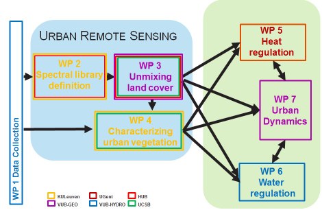
This project aims at exploring the potential of the combined use of recent multi- (including thermal) and hyperspectral sensors in combination with structural information derived by LiDAR, for detailed, characterisation of morphological and (bio)physical properties of the urban environment. By incorporating remote sensing derived information on the characteristics of green and built-up areas in the monitoring of water and heat fluxes, we strive at improving our understanding of the linkages between urban ecosystem structure and function, and of the mitigating role of urban green. This will contribute to a better assessment of urban ecosystem services related to temperature and water regulation. The dynamics of the urban environment will be accounted for by coupling biophysical modelling approaches (urban climate, hydrology) to urban growth simulation, enabling us to assess the impact of future urban development on the resilience of the urban ecosystem.
To achieve these goals we will develop in this proposal a joint framework for urban ecosystem monitoring and modelling, focusing on regulating ecosystem services (urban climate, urban hydrology) and bringing together a consortium of experts in remote sensing of urban areas and vegetation, complemented by experts on urban modelling (urban hydrology, urban climate, urban dynamics), spatial planning and urban green management. More specifically the research objectives can be detailed as follows:
- Explore the potential of innovative approaches for spectral unmixing for improved land cover parameterisation of urban biophysical models, using airborne hyperspectral data, and assess the transferability of the approaches proposed to imagery of lower spatial and/or spectral resolution acquired by current and future spaceborne multispectral and hyperspectral sensors (EnMAP, HyspIRI, Sentinel2, Landsat);
- Examine the use of spectral and LiDAR remote sensing data for characterising chemical and structural properties of urban vegetation for improved land cover parameterisation of urban biophysical models;
- Consolidate the above mentioned chemical and structural properties of the urban environment, derived by remote sensing, by defining typology that is far better suited to characterize urban climatic conditions than traditional land cover datasets typically employed for urban climate modelling;
- Develop a quantitative ecosystem service mapping tool on urban water regulation making optimal use of the detailed, high-resolution remote sensing based characterisation of the urban ecosystem;
- Develop a simulation framework for assessing impacts of urban growth and alternative urban planning scenarios on urban heat and water regulation, based on an integration of agent-based modelling of human activities at neighbourhood level, and grid-based, remote sensing supported modelling of biophysical processes.
The first two objectives will lead to generic image processing tools for characterising urban land cover, including a functional characterisation of the urban vegetation derived from different sensor platforms. At the same time our analysis will provide improved insight in which level of detail (which types of materials, vegetation types, and characteristics) can be provided at different spectral and spatial resolutions as an input for urban biophysical modelling. The last three objectives specifically aim at exploiting these remote sensing inputs for integration in urban environmental models. As such we aim at improving our understanding of heat and water regulation in urbanised areas in relation to urban form and function, and will develop tools that may assist planners in assessing impacts of alternative urban development strategies on the quality of the urban environment.
Project partners
- FORSIT, Research unit – University of Ghent (UGent, Belgium)
- Centre for Remote Sensing and Earth Observation (TAP) - Flemish Institute for Technological Research (VITO, Belgium) vito.be
- IRI THESys, Research Unit – Humboldt University (Germany) www.hu-berlin.de
- VIPER Lab, Research Unit - UC Santa Barbara (UCSB, USA) www.geog.ucsb.edu
- BNL, Research Unit – University Of Louvain (KULeuven, Belgium) aow.kuleuven.be
- Cartography and GIS, Research Unit – Free University of Brussels (VUB, Belgium) www.vub.ac.be
- HYDR, Research Unit – Free University of Brussels (VUB, Belgium)
