Mapping Kinshasa
Johan Lagae was invited to contribute to the exhibition “Afropolis: Stadt, Medien, Kunst” (curators: Kerstin Pinther, Christian Hanussek, Larissa Förster) with a presentation on the spatial development of Kinshasa, the capital city of the Democratic Republic of the Congo.
During a research seminar organized during the 2010–2011 academic year and supervised by Johan Lagae, Luce Beeckmans and Guy Châtel, students developed a presentation entitled ‘Mapping Kinshasa’, which was further refined during the summer of 2010 in collaboration with three students (Daan De Vree, Sam Lanckriet and Loïc de Bethune).
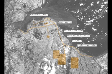
In a series of seven panels, the urban form of Kinshasa was dissected as a ‘palimpsest’ and a ‘patchwork’. Six prominent urban structures organized the narrative of the city’s spatial development: monumental axes, railroads, the ‘zone neutre’, the Avenue Kasa Vubu, planned neighbourhoods and the Rond Point Victoire.
The exhibition also travelled to other locations in Germany and Africa.
Project Info
Research group: Theory and History of Architecture
Duration: from 10-12-2010 until 13-03-2011
Researchers: Johan Lagae, Luce Beeckmans, Guy Châtel and in collaboration with students: Nele De Raedt, Maarten De Pestel, Loïc De Bethune, Kim De Raedt, Sam Lanckriet, Celine Fénaux, Arthur Van Cauwenberge, Sietse Van Doorslaer, Adrian Verhoijsen, Daan De Vree en Marie Vanderghote
